Select Item below to DOWNLOAD - Once item is selected, right click and choose 'save as'
09b527da-72c7-46bc-ac13-4cd83e0a3c65
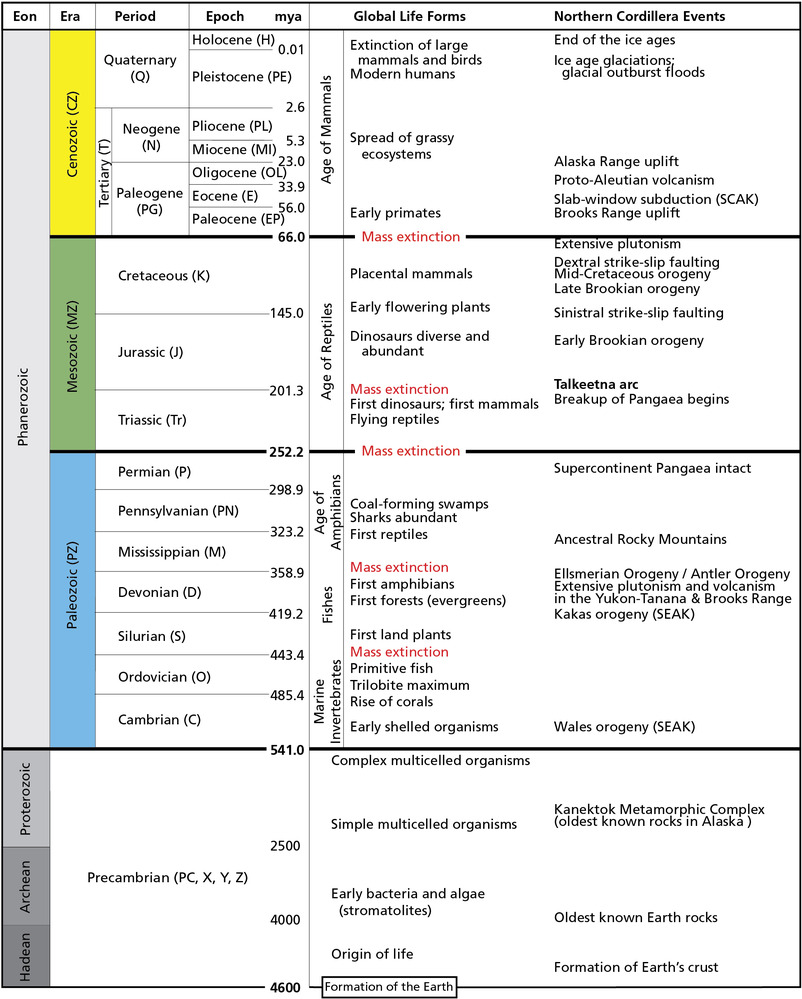
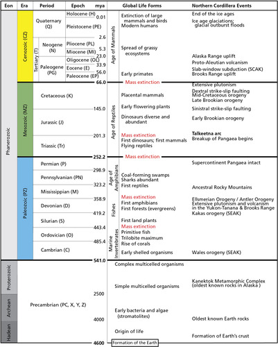
Geologic Time Scale
Geologic time scale showing the onset of major global evolutionary events and tectonic events of the North American continent and the Northern Cordillera.
Geologic time scale showing the onset of major global evolutionary events and tectonic events of the North
American continent and the Northern Cordillera. SCAK = south-central Alaska. SEAK = southeast Alaska. The divisions
of the geologic time scale are organized stratigraphically, with the oldest divisions at the bottom and the youngest at
the top. GRI map abbreviations for each time division are in parentheses. Plate 2 (in pocket) shows the ages of rock
types within the Katmai area. Ages are millions of years ago (MYA)
Permission must be secured from the individual copyright owners to reproduce any copyrighted materials contained within this website. Digital assets without any copyright restrictions are public domain.
International Commission on Stratigraphy
Public domain:Full Granting Rights
Image
Alagnak Wild River, Code: ALAG
Katmai National Park and Preserve, Code: KATM
Katmai National Park and Preserve, Code: KATM
Alagnak Wild River, Lake and Peninsula Borough, Alaska
Latitude: 59.003101348877, Longitude: -156.082000732422
Katmai National Park and Preserve, Alaska
Latitude: 58.5661087036133, Longitude: -154.889404296875
Latitude: 59.003101348877, Longitude: -156.082000732422
Katmai National Park and Preserve, Alaska
Latitude: 58.5661087036133, Longitude: -154.889404296875
01/01/0001
Public Can View
Friday, September 3, 2021 11:57:56 AM
Friday, September 3, 2021 1:01:56 PM
06_KATM_Geo Time Scale - Alaska Tectonics-01.jpg
Monday, January 1, 0001 12:00:00 AM
jpg
984.7 kB
Scenic