Select Item below to DOWNLOAD - Once item is selected, right click and choose 'save as'
07979c8c-81a1-489c-884a-3c7b944c8301
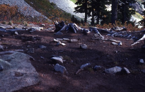
Cascade Pass site TH10 campsite early impact, 10/16/1976
A clearing with a large dirt patch studded with rocks and fallen logs. In the left corner of the image is some netting. In the background is a forested area. In the distance are mountainsides.
Cascade Pass, Revegetation Site TH10, revegetation monitoring photograph. Text on slide frame reads: "REV/CAS/TH10-2, Campsite Pass Campsite #10 of Thornburgh c/f Thornburgh 8/69 (Roll 3, Negative (3)), NPS Photo by Dan Taylor, 10/16/1976." (North Cascades NPS Complex Museum Collection, NOCA.0013 Revegetation Program Records, Series XI: Photographs, File 001 - Cascade Pass Vicinity Impacts and Revegetation Sites, 1970-2004)
U.S. National Park Service
This digital asset is in the public domain. When using this asset for any purpose, including online, credit: 'Courtesy of North Cascades NPS Complex Museum Collection, Revegetation Program Records.'
NPS Photo
Public domain
Native Plant Restoration, (North Cascades Program)
, Cascade Pass, (North Cascades Locality)
, Revegetation, (North Cascades Activity)
, Cascade Pass, (North Cascades Locality)
, Revegetation, (North Cascades Activity)
Image
North Cascades National Park, Code: NOCA
North Cascades National Park, Washington
Latitude: 48.8278884887695, Longitude: -121.35050201416
Cascade Pass
Latitude: 48.8278884887695, Longitude: -121.35050201416
Cascade Pass
ICMS Archives Module : NOCA.0013.11.001
2024/02/08
10/16/1976
slide transparency
Curation Facility
Public Can View
Person: NOCA Curator
Organization: North Cascades NPS Complex
Position: Museum Curator
Address: 7280 Ranger Station Road, Marblemount, WA 98267
Email: NOCA_Curator@nps.gov.
Organization: North Cascades NPS Complex
Position: Museum Curator
Address: 7280 Ranger Station Road, Marblemount, WA 98267
Email: NOCA_Curator@nps.gov.
Thursday, January 30, 2025 5:16:34 PM
Thursday, January 30, 2025 5:16:34 PM
0013.11.001.0590.tif
tif
34.1 MB
Monitoring