Select Item below to DOWNLOAD - Once item is selected, right click and choose 'save as'
06350be4-a3b6-4af8-bae6-caaaba4e2420
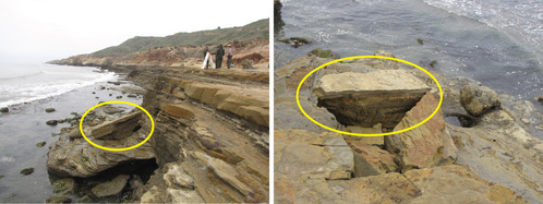
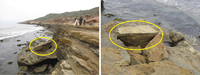
Cliff Failure
Two photographs of cliff failure showing the side and overhead view of a large (about 0 ft long) chunk of sandstone that collapsed.
On 21 May 2011, a large chunk of Point Loma sandstone broke away from the cliff after a night of large waves at a 2-m (6-ft) high tide. The event highlights the potential for sudden changes to occur (overnight) along the sea cliffs in the monument. The right photograph shows a view from above, looking down about 5 m (15 ft) from what remains of the edge.
Permission must be secured from the individual copyright owners to reproduce any copyrighted materials contained within this website. Digital assets without any copyright restrictions are public domain.
NPS photographs from National Park Service (2016a).
Public domain:Full Granting Rights
Image
Cabrillo National Monument, Code: CABR
Cabrillo National Monument, San Diego County, California
Latitude: 32.6721992492676, Longitude: -117.241996765137
Latitude: 32.6721992492676, Longitude: -117.241996765137
01/01/0001
Public Can View
Tuesday, July 20, 2021 12:26:38 PM
Tuesday, July 20, 2021 2:08:54 PM
25_Cliff_Failure_CABR_NPS_Photos-01.jpg
Monday, January 1, 0001 12:00:00 AM
jpg
1.3 MB
Scenic