Select Item below to DOWNLOAD - Once item is selected, right click and choose 'save as'
049472a9d78b40a5bec8af747bc8c9a7
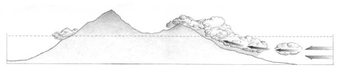
Precipitation pattern: wet verses dry. An elevation diagram of east Maui, illustrating the precipitation pattern and areas of relative wetness and dryness.
Precipitation pattern: wet verses dry. An elevation diagram of east Maui, illustrating the precipitation pattern and areas of relative wetness and dryness.
Abbr=WE
U.S. National Park Service
Reflective Art
Government owns art and all reproduction rights.
Public domain
Image
Haleakala National Park, Code: HALE
Haleakala National Park, Maui County, Hawaii
Latitude: 20.7073001861572, Longitude: -156.149002075195
Latitude: 20.7073001861572, Longitude: -156.149002075195
Image Management System : IMS 09951
20190904
01/01/1986 - 12/30/1986
Image_Size=26-1/2" x 4-1/2"; Count:18/23; Exhibit 16/Graphic # 16-9
O 5
Public Can View
Organization: Harpers Ferry Center
Address: Harpers Ferry Center, 67 Mather Place, Harpers Ferry, WV, 25425, 304-535-5050
Address: Harpers Ferry Center, 67 Mather Place, Harpers Ferry, WV, 25425, 304-535-5050
Friday, October 4, 2019 12:23:13 PM
Friday, October 4, 2019 12:23:13 PM
09951.jpg
jpg
25.4 kB
Museum