Select Item below to DOWNLOAD - Once item is selected, right click and choose 'save as'
04039541-d933-407f-8502-31f7b76bee7b
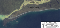
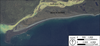
Beach Berms
Satellite image of beach berms forming at the outlet of the Swikshak River.
Satellite (IKONOS) image of beach
berms forming at the outlet of the Swikshak
River. Sediment output from the sedimentladen river is greater than the rate of erosion
by waves.
Permission must be secured from the individual copyright owners to reproduce any copyrighted materials contained within this website. Digital assets without any copyright restrictions are public domain.
IKONOS
Public domain:Full Granting Rights
Image
Alagnak Wild River, Code: ALAG
Katmai National Park and Preserve, Code: KATM
Katmai National Park and Preserve, Code: KATM
Alagnak Wild River, Lake and Peninsula Borough, Alaska
Latitude: 59.003101348877, Longitude: -156.082000732422
Katmai National Park and Preserve, Alaska
Latitude: 58.5661087036133, Longitude: -154.889404296875
Latitude: 59.003101348877, Longitude: -156.082000732422
Katmai National Park and Preserve, Alaska
Latitude: 58.5661087036133, Longitude: -154.889404296875
01/01/0001
Public Can View
Friday, September 3, 2021 1:19:01 PM
Friday, September 3, 2021 2:15:34 PM
79_KATM_Fig_Beach Berms.jpg
Monday, January 1, 0001 12:00:00 AM
jpg
1.5 MB
Scenic