Select Item below to DOWNLOAD - Once item is selected, right click and choose 'save as'
029092c8-7894-4788-8a19-173ef150a36c
54thChargeFortWagner_map.jpg
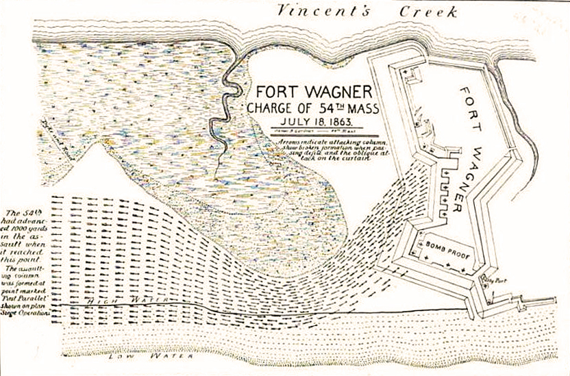
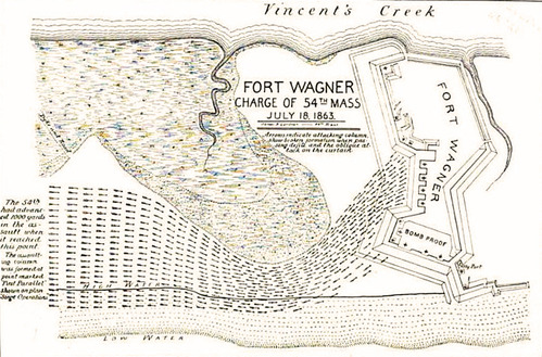
A map of the charge of the 54th Massachusetts at Fort Wagner, on July 18 1863. Vincent's Creek is at the top of the image, while Fort Wagner is depicted on the left. Low water is at the bottom of the image. Lines depicting soldiers maneuver around an inlet and head towards the fort from the right.
Fort Wagner, Charge of 54th Mass. map
For the 54th Massachusetts Regiment story map on the Boston African American National Historic Park website
scanned by Google Books from Luis Fenollosa Emilio, History of the Fifty-Fourth Regiment of Massachusetts Volunteer Infantry, 1863-1865 (Boston MA: Boston Book Company, 1894), 88. Sized, cropped, and adjusted by John Osborne, Dickinson College, June 5, 2010.
Public domain:scanned by Google Books from Luis Fenollosa Emilio, History of the Fifty-Fourth Regiment of Massachusetts Volunteer Infantry, 1863-1865 (Boston MA:Boston Book Company, 1894), 88 and Sized, cropped, and adjusted by John Osborne, Dickinson College, June 5, 2010.
Image
Boston African American National Historic Site, Code: BOAF
Boston African American National Historic Site, Suffolk County, Massachusetts
Latitude: 42.3578987121582, Longitude: -71.0706024169922
Latitude: 42.3578987121582, Longitude: -71.0706024169922
https://hd.housedivided.dickinson.edu/node/32650
1894 & 2010
01/01/0001
Public Can View
Organization: Dickinson College
Thursday, October 28, 2021 10:59:22 AM
Thursday, October 28, 2021 11:07:38 AM
54thChargeFortWagner_map.jpg
Monday, January 1, 0001 12:00:00 AM
jpg
533.9 kB
Historic
,
Map