Select Item below to DOWNLOAD - Once item is selected, right click and choose 'save as'
786142b1-2177-47df-9d42-d18a1a6a6205
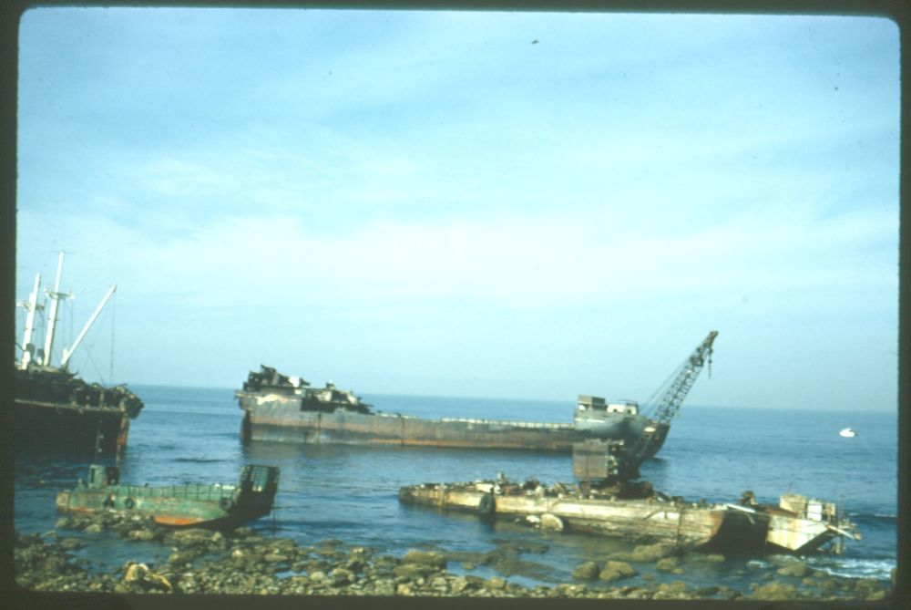
Sample images of the wreck of Dominator (built 1944; cargo vessel, Libery ship) off of Rocky Point, Palos Verdes, California
These are various views of the wreck of Dominator (built 1944; cargo vessel, Liberty ship) as it breaks-up off-shore, Los Angeles County. Some images in this group of slides are stamped as from Allen Miller, Palos Verdes, California, and it is possible that some may have been taken by him. The Dominator was a Greek-owned ship which became stranded off of Rocky Point, Palos Verdes, California, en route from Vancouver, B.C., to Los Angeles on March 14, 1961. Navigating in the fog, the vessel ran aground and for two days the crew remained, hoping tugboats would be able to pull her back out into deeper waters. The waves were unyielding and she was determined a loss. The cargo of beef and wheat was auctioned-off and scrap was pulled from the hull before she broke-up and sunk.
Remains of Dominator (built 1940; cargo vessel, Liberty ship), broken up off Rocky Point, Palos Verdes, California
U. S. National Park Service
For more information or to request a reproduction, use this <a href="http://www.nps.gov/safr/historyculture/researchcontact.htm">link</a> to contact the Park's Reference staff.
Permission must be secured from the individual copyright owners to reproduce any copyrighted materials contained within this website. Digital assets without any copyright restrictions are public domain.
Restrictions apply on use and/or reproduction:This image is for research and study purposes only. This work may be protected by U.S. copyright law (Title 17, U.S. Code), which governs reproduction, distribution, public display, and other uses of protected works. Uses may be allowed with permission from the copyright holder, or if the copyright on the work has expired, or if the use is "fair use" or within another exemption. The user of this work is responsible for compliance with the law.
Image
San Francisco Maritime National Historical Park, Code: SAFR
United States ; California ; Palos Verde, San Francisco Maritime National Historical Park, San Francisco County, California
Latitude: 33.732906, Longitude: 118.432732
Latitude: 33.732906, Longitude: 118.432732
Other : safr_22584_p95-012-4-1-02-01_sl_frt_pres : Historic Documents Department (HDD) local file name
Other : safr_22584_p95-012-4-1-02-05_sl_frt_pres : Historic Documents Department (HDD) local file name
Other : safr_22584_p95-012-4-1-02-10_sl_frt_pres : Historic Documents Department (HDD) local file name
Other : safr_22584_p95-012-4-1-02-11_sl_frt_pres : Historic Documents Department (HDD) local file name
Other : safr_22584_p95-012-4-1-02-13_sl_frt_pres : Historic Documents Department (HDD) local file name
ANCS : SAFR 22584
Local Park number : P95-012, Series 4.1, File Unit 02, Slides 01, 05, 10, 11 & 13
Legacy NPS Focus Record ID : 471433
Title: A guide to the Arthur J. Thompson photographs, 1939-1973
URL: http://www.oac.cdlib.org/findaid/ark:/13030/c8hx1c0d/
URL: http://www.oac.cdlib.org/findaid/ark:/13030/c8hx1c0d/
03/23/2012 | Published to NPS Focus
04/10/1961 - 06/07/1962
5 color slides
P95-012; Box 5, Folder 7
Image
Friday, March 23, 2012 4:03:26 PM
Wednesday, June 12, 2013 3:25:52 PM
SAFR-98f55c79cb7445cf99f6c5b41c5a46d2.tif
Epson Epson, Exp10000XL
Tuesday, January 17, 2012 10:49:40 PM
tif
8.7 MB
Scenic
,
Historic
Sample images of the wreck of Dominator (built 1944; cargo vessel, Libery ship) off of Rocky Point, Palos Verdes, California
Sample images of the wreck of Dominator (built 1944; cargo vessel, Libery ship) off of Rocky Point, Palos Verdes, California
Sample images of the wreck of Dominator (built 1944; cargo vessel, Libery ship) off of Rocky Point, Palos Verdes, California
Sample images of the wreck of Dominator (built 1944; cargo vessel, Libery ship) off of Rocky Point, Palos Verdes, California